Design drawing featuring cross section for Coburg Road with new multi-use path, sidewalk and roadway
The municipality is currently improving multi-modal transportation on Coburg Road through the addition of a multi-use pathway, improvements to pedestrian crossings, and roadway recapitalization. Construction is happening this year, with expected completion by October 2024. The municipality is partnering with Halifax Water to perform maintenance on the water and sewer systems at the same time. Collaboration with Halifax Water on projects helps to minimize impact to the public as a result of construction and provides opportunities for cost savings.
This project is part of the Halifax Urban Greenway, including a multi-use pathway that is part of the municipality’s regional multi-use pathway system providing key connections that contribute to our regional all ages and abilities active transportation network. The Halifax Urban Greenway helps make important connections within the community between schools and other facilities, Conrose Park and surrounding neighbourhoods. The Halifax Urban Greenway is also supported by the municipality’s Integrated Mobility Plan which provides guidance for improving accessibility and prioritizing the movement of people through various travel modes.
This project’s design uses current Municipal Design Guideline criteria to establish improved pedestrian and cycling facilities, while maintaining the existing functionality of the street. With the narrowed street and existing on-street parking, it will provide a traffic calming effect. The appropriate and expected yielding to oncoming traffic on the local street will remain unchanged. Please see below for more details about this project.
Current status
Construction has started and crews are on site completing the work. The project is expected to finish in October 2024. Current and planned efforts include:
- Halifax Water watermain replacement, water testing, pressurizing the new line and installation of catch basins along the street. For detailed specifics on this portion of the project visit Halifax Water’s website.
- The municipality will continue with removals, and utility relocations. Next steps include new curb and gutter, paving and landscaping.
This space will be updated as project status changes.
More about the Halifax Urban Greenway
The Halifax Urban Greenway was originally planned by a south end community group as an approximately five kilometre active transportation corridor linking Point Pleasant Park to the Chain of Lakes Trail. The municipality worked with the community to construct the initial segment along Beaufort Avenue between South Street and Marlborough Woods. Upgrades have also been completed in Conrose Park. Work is ongoing to make the connection on Coburg Road. Future segments are being developed to connect Saint Mary’s University to the south, the West End Mall site to the north, and on municipal streets as recapitalization opportunities on streets present themselves.
For additional background information about the Halifax Urban Greenway and related public engagements and discussions visit the (now archived) Shape Your City webpage.
Questions and answers
- When will the work be complete?
The project is expected to be completed in October 2024. It is important to get any work done before it gets too cold to pave or do concrete work.
- What changes are being made along Coburg Road and where?
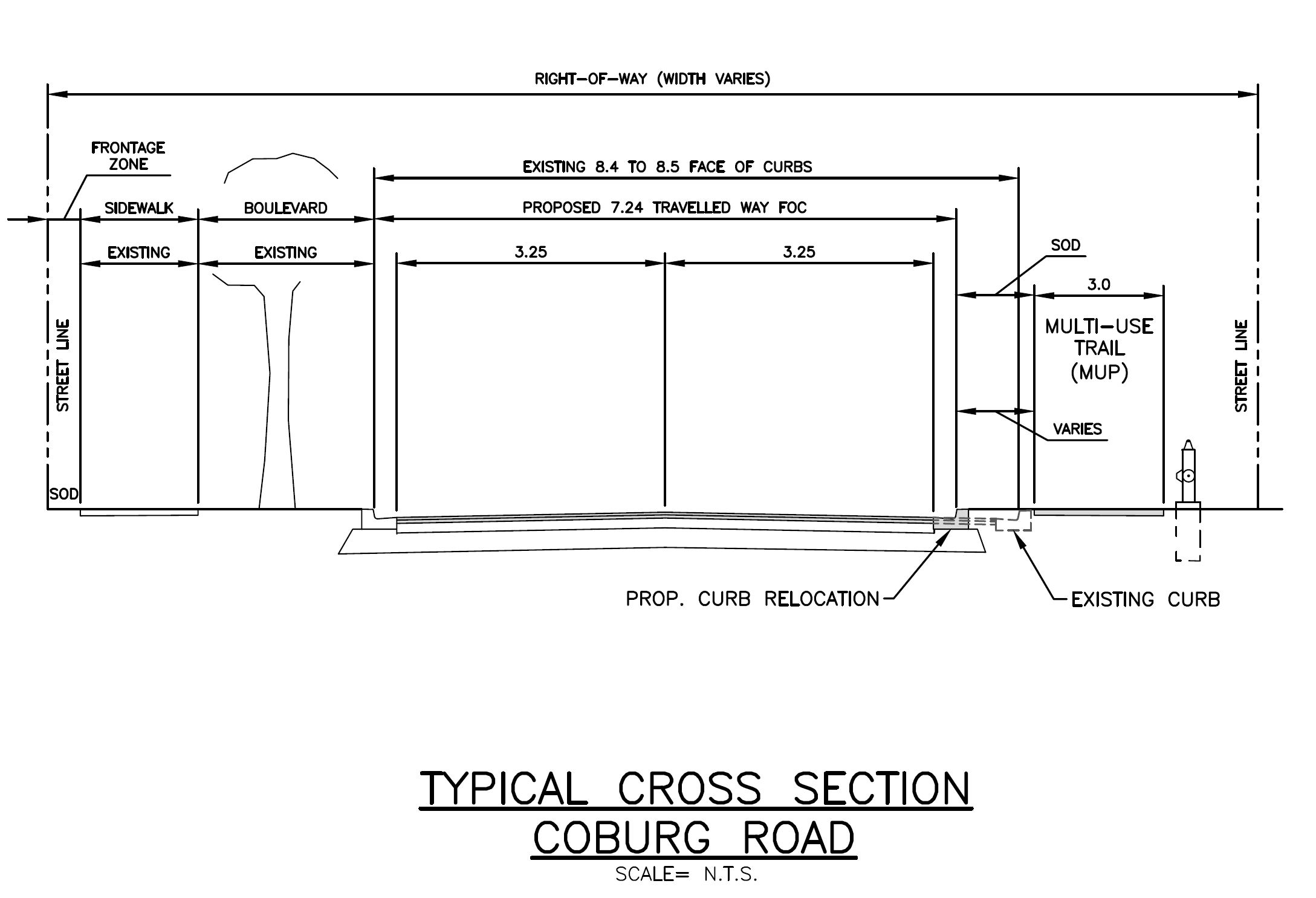
In addition to work being led by Halifax Water (detailed on their website), construction is taking place on the western edge of Coburg Road between Oxford Street and the CN bridge. The work includes replacing the existing sidewalk along the southside of the road and replacing it with a three-metre-wide multi-use pathway. This design meets the typical design standard for multi-use pathways to allow comfortable, bi-directional travel for those who walk, roll or cycle.
The sidewalk on the north side of this section of Coburg Road will remain the same.
To improve user experience, the asphalt along Coburg Road will be repaved from Oxford Street to the western end of the road.
- Will any trees be impacted by this project?
Approximately 14 younger trees will be impacted by this work, while no impacts are expected to mature trees within the area. As part of the project, 20 new trees will be planted – three within the project area, and 17 in other areas along the Coburg Road corridor.
- Will on-street parking be impacted?
There is no current plan to remove any on-street parking.
- Is the road being narrowed?
Yes, the road width, from the face of the curb to the face of the curb, will be narrowed by up to 1.26 metres in certain segments. At the narrowest point, the new road width will be 7.24 metres wide, from face of curb to face of curb.
This narrowing is necessary to upgrade the sidewalk to a multi-use pathway, improving conditions for those who walk, roll or cycle through the area, while continuing to support the traditional street uses. The overall design, including road width and other aspects of the street, meets the standards for safety and functionality as established in the Regional Council-approved Municipal Design Guidelines. As such, the new road width allows for emergency response vehicles, such as fire trucks. These standards have been established in consultation with emergency services such as Halifax Regional Fire & Emergency, and processes are in place to ensure designs like this one meet these standards before being approved for construction.
- Do the changes that are being made impact the way we will use the street?
No. Generally, the street will remain the same and is intended to function the same way it always has with the added benefit of improved transportation considerations and conditions for those who walk, roll or cycle.
- Is this project unique?
No, multi-use-pathways are common in many places in the municipality and across North America. Examples of these pathways in the municipality include Prince Albert Road and Baker Drive in Dartmouth, Beaufort Avenue and Ahern Drive in Halifax and Broad Street in Bedford. Additional information about multi-use pathways within the municipality can be found on our website.
- How was the project planned?
The Halifax Urban Greenway was originally planned by a south end community group as an approximately five-kilometre-long active transportation corridor linking Point Pleasant Park in the south to the Chain of Lake Greenway to the north. The design plan for this project was chosen based on the previous functional planning and public engagement completed by the municipality in 2018 Halifax (see the archived Halifax Urban Greenway Shape Your City webpage for backghround). This will provide a safe, comfortable, convenient, and consistent active transportation facility for people of all ages and abilities from Conrose Park multi-use pathway to a future multi-use pathway on Oxford Street. Eventually this will connect to an expanded Halifax Urban Greenway.
This project includes a short 180 metre length multi-use pathway on the south side of Coburg Road to connect the multi-use pathway in Conrose Park to Oxford Street.
- Is the road width unique?
The design of the public street right of way and infrastructure within it meets all of the standards required to provide safety and functionality. Similar roads widths can be found across the municipality including Grant Street and Stanhope Street off Tower Road on the Halifax peninsula.
Project contact
For more project information please call “311” or email us at contactus@311.halifax.ca.